Atlas Spectral KIT Has Your Harvests Under Control
Drones, or unmanned aerial vehicles (UAVs), are becoming very popular with small farmers and large agriculture companies for offering an easy way to take a look at their fields. They now use detailed images from these “modern birds” as a more advanced tool for estimating the quality of their yields.
It sounds strange, but it is actually very simple: it is no longer necessary to hire individual specialists or to make a tour of the crops yourself at every stage of the process. Drones can scan crops of up to 10 km2 (6 sq mi) in less than an hour. All this can be done even in strong wind or rainy weather. This, in turn, will significantly reduce the cost of the logistics of the farm fleet, as well as the cost of products to help protect the health of the plants.
All this is achieved without leaving the office. For example, according to certain studies drones are already increasing the harvest per hectare by 2-4%, transforming the technological approach to farming. Fascinating, isn’t it?
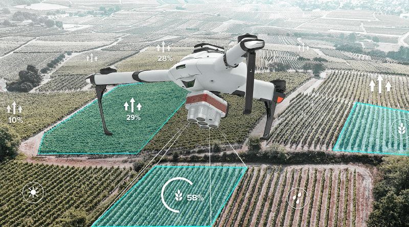
ATLAS has worked on various customers’ inquiries and has learned the issues they face methodically and carefully. As a result, the company has integrated AtlasPro drones with the Altum multispectral camera by MicaSense, the leader in the multispectral camera industry, in order to fully take in and understand the situation of large areas of crops.
Atlas Spectral KIT is an innovative solution for agriculture. You get accurate details of your crop in all weather conditions in just one flight at a minimal cost.
How does Atlas Spectral KIT work?
Many agriculture companies were using satellite images in the past for understanding the state of their crops. But these photos were not ideal for detailed research of the situation in different field segments.
Aerial photography from a UAV is more detailed than a satellite image. It is possible to have a resolution of images in centimeters (inches) per point, due to flight altitudes from 100 to 500 meters (328 to 1640 ft) above the ground. Furthermore, UAVs allow imaging even in cloudy conditions, which is inaccessible to satellites and complicates the use of aviation. Altum captures thermal, multispectral, and high-resolution imagery with one single sensor.
An ATLAS manager of enterprise solutions says:
“Atlas Spectral KIT allows you to data acquisition on plant health, phenotype, and water stress in a single flight, by capturing six bands during flight: red, green, blue, red edge, near-infrared and thermal. The capture of these bands happens at the same moment, making the data easier to align and use for analytics. Also, because there are six bands, data can be used to create anything from DVI to digital surface models to thermal heat maps. There are significant savings in survey costs and time compared with all other types of surveys; ground surveys, satellite photos, and manned aircraft”.
What you can use Atlas Spectral KIT for:
- For soil and field analysis
At the beginning, middle, and end of the crop cycle, you can use Atlas Spectral KIT to obtain useful data on soil composition and quality. Using 3D soil maps, you can diagnose the presence of soil composition, nutrient levels, or dead spots promptly. This information can help farmers determine the most effective planting and growing patterns, soil care, etc. - For spraying crops
Consistent fertilization and spot spraying are required to maintain rich crops. For example, if a fungus has been found in a limited area, you can quickly and accurately identify it rather than spraying the whole area. This way, you will save time and resources. - For assessing plant health
With sensors that take pictures in different color spectra, you can determine plant health based on light absorption, instantly giving you an overall picture of a farm’s health. - For monitoring and organizing irrigation operations
Irrigation is a hassle. If your irrigation systems stretch for kilometers (miles), there’s no escaping the hassle. Atlas Spectral KIT can diagnose irrigation problems or areas with too little or too much moisture.
You can survey more areas in AtlasMESH. AtlasMESH transmission systems allow users to operate several UAVs in tandem, while each drone communicates with the rest of the swarm, which significantly speeds up the data acquisition process. This is the best solution for quick remote mapping operations of large areas, even in tough conditions.
You can research big areas non-stop without a human in a field with AtlasNEST. AtlasNEST is a smart protective and charging station that allows for autonomous takeoff and landing, as well as battery charging and swapping for the AtlasPro, enabling UAV relaunch in less than 3 minutes.
The user sets all missions remotely from a control hub and thus keeps track of when to harvest.
The Atlas Spectral KIT is the ultimate solution for precision, flexibility, and profitability in your agricultural operation.
More information:
Ivan Tolchinsky, ATLAS CEO, pr@atlasdynamics.eu


